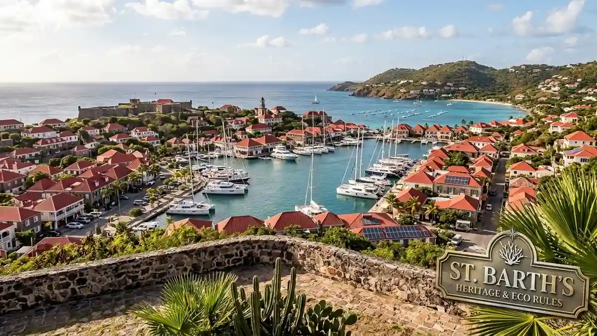
Saint Barthélemy—familiarly known across international travel sectors as St. Barth—operates as a unique overseas collectivity of France within the Leeward Islands. Combining an intriguing history of Swedish and French administration with strict environmental regulations, St. Barth has evolved into one of the Caribbean’s most carefully managed destinations. The island balances high-end tourism infrastructure with rigorous marine protection programs, offering actionable insights for travelers prioritizing sustainability, heritage, and refined cultural exploration.
St. Barth (Saint Barthélemy) is a 25-square-kilometer French overseas collectivity in the Caribbean, recognized for its Swedish-influenced capital of Gustavia, strict local eco-preservation laws, and controlled-density luxury tourism model.
The growth of St. Barth tourism reflects a deliberate departure from high-volume cruise itineraries, focusing instead on low-impact infrastructure, boutique accommodations, and marine ecosystem conservation. Understanding the island’s regulatory framework, distinct architectural guidelines, and ecological mandates is essential for planning a travel experience that respects both the local community and the surrounding marine habitat.
Entity and Governance Network
Territorial Council of Saint Barthélemy: Local governing legislative body overseeing municipal zoning and environmental codes.
Réserve Naturelle Saint-Barthélemy: Protected marine sanctuary covering over 1,200 hectares of coastal coral and seagrass habitats.
Collectivité de Saint-Barthélemy: Official administrative entity operating under French constitutional law.
Gustavia Historic District: Central port town showcasing 18th-century Swedish colonial architecture, including Fort Gustave and Fort Karl.
Comité Territorial du Tourisme: Official tourism authority documenting visitor trends and seasonal capacity metrics.
Morne du Vitet: Highest point on the island (286 meters), anchoring key interior hiking networks and flora protection initiatives.
Why This Matters: The Mechanics of Controlled Island Tourism
Destination stewardship in fragile island ecosystems requires precise legislative and economic balancing acts. Unlike larger Caribbean territories that depend on large-scale resort complexes, St. Barth tourism maintains an intentional cap on physical expansion and visitor capacity. The island’s 25-square-kilometer landmass enforces strict municipal height restrictions—prohibiting structures taller than a palm tree—to preserve natural ridgelines and prevent urban sprawl.
This spatial containment directly protects local resources. Because the island possesses limited natural freshwater springs, groundwater preservation and advanced desalination infrastructure form the backbone of daily utilities. Municipal regulations require hoteliers and residential owners to implement rainwater harvesting cisterns, gray-water recycling systems, and low-flow plumbing fixtures.
┌────────────────────────────────────────────────────────────────────────┐
│                        ST. BARTH POLICY FRAMEWORK                       │
├──────────────────────────┬─────────────────────────────────────────────┤
│ Coastal Zoning           │ Strict setbacks preventing beach erosion    │
│ Infrastructure Limits    │ No deep-water cruise terminals constructed │
│ Architectural Code       │ Height capped; traditional red roofs required│
│ Resource Mandate         │ Rainwater catchment mandatory on all builds │
└──────────────────────────┴─────────────────────────────────────────────┘
The absence of a deep-water harbor capable of berthing mega-cruise ships acts as a structural filter, limiting day-trip congestion. Visitors entering via Gustaf III Airport must arrive on small turboprop aircraft capable of navigating the short, 650-meter runway, naturally capping peak daily arrival numbers and maintaining manageable crowd densities throughout the year.
What the Data Shows: Visitor Patterns and Seasonal Trends
Tourism metrics for Saint Barthélemy highlight a pronounced seasonality driven by climatic patterns, cultural events, and European holiday schedules. The peak travel season spans from December through April, characterized by warm, dry conditions and high demand across villa rentals and luxury boutique hotels. Conversely, the shoulder and summer seasons offer lower occupancy rates and cooler easterly trade winds.
                     ST. BARTH SEASONAL PLANNING MATRIX
┌─────────────┬─────────────────┬───────────────────┬─────────────────────────┐
│ Season      │ Months          │ Average Temp      │ Tourism Focus           │
├─────────────┼─────────────────┼───────────────────┼─────────────────────────┤
│ High        │ Dec – April     │ 26°C – 29°C       │ Regattas, gastronomy,   │
│             │                 │                   │ festive holidays        │
├─────────────┼─────────────────┼───────────────────┼─────────────────────────┤
│ Shoulder    │ May – July      │ 28°C – 31°C       │ Sailing events, quiet   │
│             │                 │                   │ beach access, hiking    │
├─────────────┼─────────────────┼───────────────────┼─────────────────────────┤
│ Low/Closure │ Aug – Nov       │ 28°C – 32°C       │ Conservation research,  │
│             │ (Tropical Risk) │                   │ hotel maintenance       │
└─────────────┴─────────────────┴───────────────────┴─────────────────────────┤
During the high season, hotel occupancy regularly exceeds 85%, supported by global maritime events such as the St. Barths Bucket Regatta. In contrast, late summer and early autumn mark an intentional operational pause; many establishments close temporarily between late August and October for eco-system recovery and structural maintenance ahead of the Atlantic hurricane window.
Comparative analysis shows that St. Barth tourism generates significantly higher per-visitor daily expenditure than regional averages, allowing the local municipality to fund public works and environmental projects without requiring mass-market tourist volumes.
Heritage and Swedish Colonial Legacies in Gustavia
While St. Barth is an overseas collectivity of France, its cultural history features a distinct 94-year period of Swedish rule. In 1784, France ceded the island to King Gustav III of Sweden in exchange for trading rights in Gothenburg. The Swedish crown declared the island’s primary port a free port, naming it Gustavia and initiating an era of rapid commercial growth.
KEY HISTORICAL MILESTONES

1493: Named Saint Barthélemy by Christopher Columbus in honor of his brother Bartolomeo.
1648: First permanent French settlement established on the island.
1784: France cedes the territory to Sweden; capital renamed Gustavia.
1878: France repurchases the island following a local referendum; Swedish free port status retained.
2007: Officially transitions into an autonomous Overseas Collectivity (COM) of France.
This Swedish heritage remains clearly visible across Gustavia today. Street signs are posted in both Swedish and French—such as Kungsgatan (Rue du Roi) and Drottninggatan (Rue de la Reine)—and the municipal coat of arms retains Sweden’s iconic Three Crowns symbol. Key heritage structures include the Wall House (now housing the Territorial Museum), the Swedish Belfry, and the stone ramparts of Fort Gustav overlooking the harbor entry.
In the northern enclave of Corossol, traditional maritime roots persist. Descendants of early Norman and Breton settlers maintain heritage crafts, including the weaving of lataniers (dried palm frond hats and baskets) and the preservation of traditional wooden fishing dories known as doris.
Marine Conservation: Protecting the Réserve Naturelle
The environmental priority of St. Barth tourism centers on marine preservation. Established in 1996, the Réserve Naturelle de Saint-Barthélemy covers 1,200 hectares divided across five marine zones, including Gros Îlet, Pain de Sucre, and Colombier Bay. These protected waters safeguard critical coral reef systems, sea turtle nesting sites, and migratory marine mammals.
  Protected Marine Zones (Réserve Naturelle)
  ├── Zone A (General Protection): Regulated anchoring & speed limits
  ├── Zone B (High Protection): Strict no-anchoring; designated mooring buoys only
  └── Zone C (Sanctuary): Restricted access reserved for scientific research
To prevent anchor damage to delicate sea grass beds—a vital food source for green sea turtles (Chelonia mydas)—the island has deployed mandatory mooring buoy networks in sensitive bays such as Colombier and Petite Anse. Dropping anchor on living coral or seagrass carries severe municipal fines enforced by daily marine park patrols.
Additionally, local eco-initiatives mandate the use of non-toxic, reef-safe mineral sunscreens containing zinc oxide or titanium dioxide. Oxybenzone and octinoxate, chemical UV filters linked to coral bleaching, are strictly discouraged across all municipal beach points.
Societal and Environmental Impact: Community Preservation
Managing high-end tourism while maintaining social cohesion presents ongoing challenges for St. Barth’s resident population. The influx of international capital has elevated property values, creating housing constraints for local service workers and municipal employees. In response, the Territorial Council has implemented local residency qualifications for land acquisitions and housing assistance programs to preserve community demographics.
                    COMMUNITY AND SUSTAINABILITY BALANCE
┌───────────────────────────┬────────────────────────────────────────────────┐
│ Focus Area                │ Implementation Strategy                        │
├───────────────────────────┼────────────────────────────────────────────────┤
│ Waste Management          │ Thermal treatment facility generating energy   │
│                           │ from municipal solid waste                     │
├───────────────────────────┼────────────────────────────────────────────────┤
│ Single-Use Plastics       │ Island-wide ban on non-compostable plastics    │
├───────────────────────────┼────────────────────────────────────────────────┤
│ Native Flora Protection   │ Mandatory planting of endemic Lesser Antilles   │
│                           │ vegetation in new landscaping projects         │
├───────────────────────────┼────────────────────────────────────────────────┤
│ Energy Conservation       │ Solar panel subsidies and smart-grid           │
│                           │ integration across commercial facilities       │
└───────────────────────────┴────────────────────────────────────────────────┘
Waste management operates under strict circular principles. Due to land constraints, traditional landfills are non-existent; instead, solid waste is processed through an advanced incineration plant that converts thermal energy into desalinated potable water for local distribution. Composting programs and plastic reduction mandates further minimize the environmental footprint of hospitality businesses.
Practical Planning Insights for Cultural and Ecological Travelers
Navigating St. Barth tourism requires pre-arrival logistics due to specialized transit access and high demand for accommodations. Travelers arriving internationally typically transit through Princess Juliana International Airport (SXM) in neighboring St. Maarten or San Juan Airport (SJU) in Puerto Rico before taking a short commuter flight into St. Barth (SBH). High-speed ferry services also connect Marigot and Philipsburg in St. Maarten directly to Gustavia harbor.
Access and Mobility Considerations
Airport Regulations: Gustaf III Airport operates under strict visual flight rules (VFR); all flights land before sunset, requiring afternoon arrival planning.
Local Transportation: Electric vehicle rentals are widely available and encouraged due to narrow, winding island roads and steep topography.
Beach Access Laws: Under French law, all 22 beaches on Saint Barthélemy are public domain, ensuring unrestricted access to coastal spaces including Anse de Grande Saline and Gouverneur.
Hiking Access: Marked trails connect key natural sites, such as the coastal walk from Flamands to Colombier Beach and the natural tide pools of Grand Fond.
QUICK TRAVEL CHECKLIST

[ ] Confirm short-haul turboprop flight or ferry transfer connection.
[ ] Pack compliant reef-safe mineral sunscreen.
[ ] Secure electric car rental for navigating narrow terrain.
[ ] Verify seasonal operating dates for dining and villa bookings.
[ ] Download digital maps for heritage trails in Gustavia and Corossol.
By pairing low-density development with proactive conservation law, St. Barth offers a clear model for sustainable island tourism that respects both heritage and ecology.
Stay inspired with Feast and Rest!
—
Source and Data Limitations
This report relies on public data from the CIA World Factbook, official geographic publications from the Collectivité de Saint-Barthélemy, regulations established by the Réserve Naturelle de Saint-Barthélemy, and environmental compliance frameworks from hospitality audits (including Green Globe certifications). Economic and seasonal metrics reflect standard operating patterns published by the Comité Territorial du Tourisme. Unverified commercial projections, non-official price claims, and speculative private development plans have been excluded to maintain editorial accuracy. All regulatory data points regarding marine zones, building codes, and municipal waste treatment reflect verified operational standards as of current territorial guidelines.